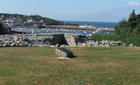
An unfinished fort in the care of English Heritage. Though named Harry's Walls, it was begun in 1551, during the reign of Edward VI. An early plan shows it was intended to be square with acutely angled bastions at each corner - an Italian design reflecting the increasing use of cannon. Internal buildings are depicted against the curtain wall on all four sides and a brewhouse and mill was to be errected next to a fresh water pool below the hill. Bad siting appears to have been the reason for completion on only the south-west side, visible as only two bastions connected by a curtain wall heavily robbed of its dressed facing stones. A well-built drain passing through this wall shows where ground level would been. A foundation trench indicates the proposed line of the north-western curtain walls. Outside stands a tall slender stone first recorded by Borlase in 1756 as sitting on a mound. Secured in position in recent years, this probably a Bronze Age menhir in its original position, with traces of surrounding cairn.
What's Nearby
-
Lower Moors Nature Trail
Fantastic for local and migrant bird life. Lower Moors exhibits a wide range of wetland habitats;...
0.09 miles away -
Lifeboat Station
Defining the harbour is the lifeboat station, inside you will find paintings, models and accounts...
0.2 miles away -
Glandore Gallery
Glandore Gallery is a beachside studio/shop featuring work by Stephen Morris and Nan Heath,...
0.33 miles away -
Scilly Walks
Scilly Walks offers guided walks, boat trips, slide shows and short break holidays to introduce you...
0.34 miles away
-
Buzza Tower
Previously called King Edward's Tower this well know landmark has been maintained since 1912 as a...
0.4 miles away -
Visitor Information Point
The Tourist Information Centre provides all the information you need to make the most of your...
0.43 miles away -
Carreg Dhu Community Garden
A 1.5 acre sub tropical garden which has been formed on several levels from an old disused ram pit...
0.53 miles away -
Hugh House
Overlooking the sandy isthmus of Hugh Town, the current offices of the Duchy of Cornwall were built...
0.58 miles away -
Telegraph Tower
This circular granite building was erected on the highest point of the Islands as a gun and...
0.77 miles away -
Garrison Walls
Fortified walls encircling the headland west of Hugh Town, begun about 1588 and added to during the...
0.87 miles away -
Higher Moors Nature Trail
This site exhibits a wide diversity of habitats with several rare and notable plant species. The...
0.9 miles away -
Bant's Carn Burial Chamber and Halangy Down Ancient Village
Set on a hill above the site of the ancient Iron Age village, lies this Bronze Age burial mound,...
0.94 miles away -
Bar Point
Between McFarland's Down and the Innisidgen Bronze Age Tombs, you will find Bar Point, one of St....
1.34 miles away -
Pelistry
Ask anyone who lives on St. Mary's why they love Pelistry and the same reasons pop up. Pelistry Bay...
1.35 miles away -
Old Man of Gugh
This leaning menhir, 2.4 metres high, is a prominent feature on the skyline. George Bonsor dug...
1.94 miles away -
Tresco Abbey Garden
Venture a stone's throw beyond the tip of the mainland and experience what is perhaps the UK's most...
2.28 miles away


 button to add an item to your Itinerary basket.


